Mesh-Network Datalinks
A drone swarm can form a dynamic network and pass data from aircraft to aircraft. The network can reorganise itself if one node is lost.
Types, Operating Principles and the Future
Unmanned aerial vehicles need a communications system to be controlled remotely, transfer mission data reliably and maintain an uninterrupted connection with their operators. The technology that provides this connection is called a data link, or datalink.
An engine may keep a UAV in the air, but the datalink connects it to the operator, enables it to carry out its mission and delivers the data it collects. Let us take a closer look at this critical technology.
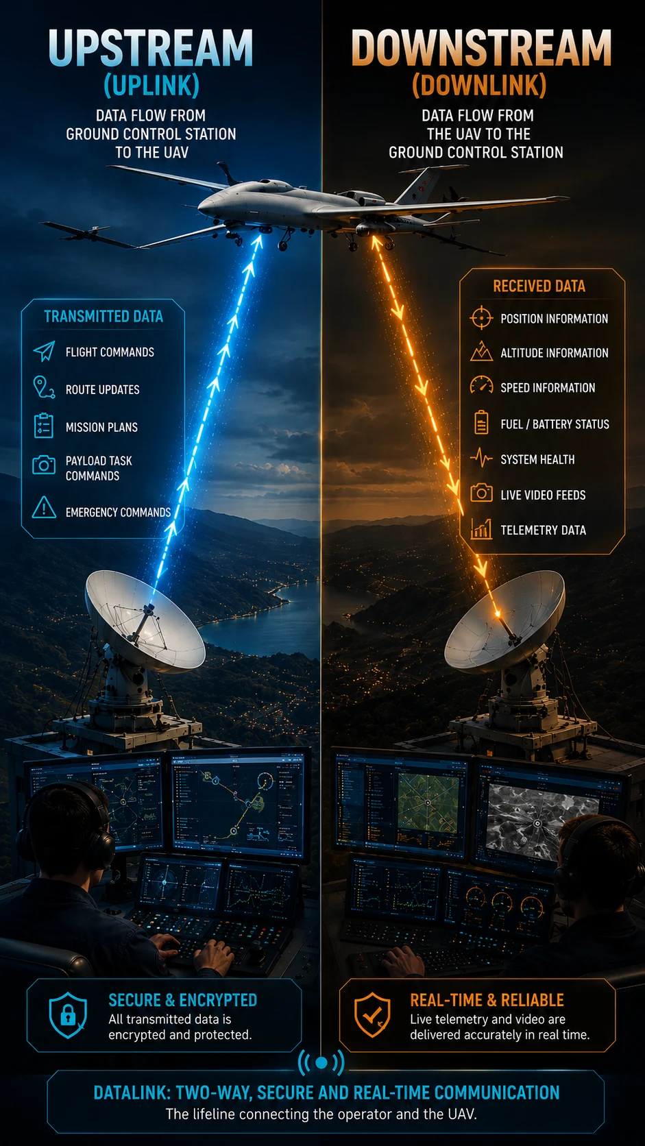
In its simplest form, a data link is a communication system that enables the secure, bidirectional, and real-time exchange of Command and Control (C2), telemetry, and mission data between two or more platforms. In unmanned aerial vehicles (UAVs), this system provides continuous communication between the Ground Control Station (GCS), the UAV, other air and naval platforms, and satellite communication systems.
Modern data link systems typically carry three primary types of data:
Data required to control the UAV, including flight commands, mission plans, route updates, payload management, software or mission parameter updates, and emergency commands such as Return-to-Home (RTH) or Abort Mission.
Operational data transmitted from the UAV to the Ground Control Station, including position, altitude, airspeed, battery or fuel status, system health, and other flight parameters that allow operators to continuously monitor the aircraft.
Information collected by the UAV's mission payloads, including Electro-Optical/Infrared (EO/IR) imagery, Synthetic Aperture Radar (SAR) data, Signals Intelligence (SIGINT), and other sensor outputs used for reconnaissance, surveillance, and intelligence missions.
Uplink refers to the flow of data transmitted from the Ground Control Station (GCS) to the UAV. This channel primarily carries Command and Control (C2) information, including flight commands, mission plans, route updates, payload control instructions, software or mission parameter updates, and critical emergency commands such as Return-to-Home (RTH) and Abort Mission.
Downlink refers to the flow of data transmitted from the UAV to the Ground Control Station (GCS). This channel carries both telemetry and payload data. It delivers real-time or near-real-time information such as live video streams, EO/IR sensor imagery, SAR radar data, system status, navigation information, and data from other onboard sensors, enabling operators to monitor both the aircraft and the mission as it unfolds.
The appropriate datalink technology varies with a UAV's mission profile. The principal architectures used today include the following:
These systems maintain a direct radio connection between the UAV and its ground control station. The two points must effectively “see” each other for reliable communication, so Earth's curvature and terrain obstacles generally limit range to about 50–150 kilometres. Their greatest advantage is very low latency: commands reach the aircraft almost instantly and imagery can be transmitted in real time. LoS links are common on short-range reconnaissance UAVs and FPV systems.
On beyond-line-of-sight (BLoS) missions, the UAV leaves the direct radio coverage of its ground control station. Communication is then maintained through a satellite communications system.
Strategic UAVs such as Bayraktar Akıncı, TB3 and ANKA-3 can connect to TÜRKSAT satellites through SATCOM terminals developed by ASELSAN and CTech. Mountains, seas and distances of thousands of kilometres therefore need not sever the link, allowing an operator to control the aircraft securely from far away.
In addition to traditional Geostationary Earth Orbit (GEO) communication satellites, Low Earth Orbit (LEO) satellite constellations such as Starlink and OneWeb are becoming increasingly important for UAV communications worldwide. Compared to GEO satellites, LEO systems provide lower latency and higher data throughput, making them particularly well suited for real-time Command and Control (C2) and the transmission of high-bandwidth mission data, such as live video and sensor feeds.
In Türkiye, next-generation satellite communication initiatives led by ASELSAN and Fergani Space aim to develop a domestic LEO ecosystem. These efforts are expected to establish the infrastructure necessary for enabling indigenous UAV data links via Turkish LEO satellite constellations in the future.
Airborne relays are useful when satellite communications are unavailable, too costly or impaired by electronic warfare. A high-altitude or persistent relay UAV acts as a bridge in the sky between the ground station and a distant mission aircraft. The relay role can also be performed by another UAV, a manned aircraft, a balloon, or a high-altitude platform.
This approach is also known to have been used in Türkiye's cross-border operations. High-altitude platforms such as TUSAŞ ANKA and AKSUNGUR can extend communications coverage for mini and tactical UAVs as well as ground units, helping sustain connectivity in mountainous terrain and deep valleys where direct links are difficult.
In civil aviation, urban cargo delivery and inspections of infrastructure such as wind turbines and power lines, UAVs are increasingly connecting directly to telecommunications towers. Network slicing in 5G can assign separate, isolated and secure bandwidth to critical flight data and camera video.
Every command sent by the operator reaches the UAV through the datalink.
Camera imagery, radar output and telemetry reach the ground station in real time.
Continuous data exchange allows multiple UAVs to operate together.
Route changes, new targets and return commands can be sent during a mission.
If the link is lost, modern UAVs can enter return-to-home or another predefined safe-flight mode.
A drone swarm can form a dynamic network and pass data from aircraft to aircraft. The network can reorganise itself if one node is lost.
QKD aims to protect data with quantum-based keys and reveal interception attempts. Research into military use continues.
Narrow laser beams can make interception and radio-frequency jamming more difficult while supporting very high data rates.
The system scans the spectrum and can move autonomously to a cleaner frequency band when interference is detected.
Compatible hardware can switch among LoS, SATCOM, 5G and future military links through software updates.
A UAV datalink is the two-way communications system that transfers command and control (C2), telemetry and mission data between a UAV and its ground control station in real time. It lets the operator send flight commands and receive data such as position, speed and camera footage back from the aircraft.
Uplink is data sent from the ground control station to the UAV, carrying flight commands, route updates and emergency commands. Downlink is data sent from the UAV back to the ground station, carrying telemetry and payload data such as camera imagery. Together they form the two-way datalink.
Modern UAVs switch to predefined safe behaviors when the link is lost, such as automatically returning to the launch point (Return-to-Home), continuing on a preset holding pattern, or executing a safe landing procedure.
A line-of-sight (LoS) datalink needs a direct radio connection between the UAV and ground station and is typically limited to 50-150 km, but has very low latency. A SATCOM datalink routes communications through satellite infrastructure, enabling beyond-line-of-sight (BLoS) control over much longer distances.
Yes, especially in military and professional UAV systems, command and control data is transmitted encrypted to prevent third parties from hijacking the aircraft or intercepting the signal. Telemetry and payload data are typically protected by similar security layers.
A datalink is more than a communications system for remote control. It underpins flight control, real-time imagery, mission management and UAV swarm coordination. A broken communications link can turn even the most advanced UAV into an isolated platform unable to complete its task. The success of a modern unmanned aircraft therefore depends on a strong, secure and continuous data connection just as much as it depends on engines, sensors and artificial intelligence.